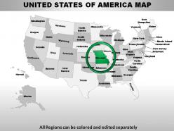
Usa missouri state powerpoint maps
Your thoughts will work out the tactics. Deploy them with our USA Missouri State Powerpoint Maps.
You must be logged in to download this presentation.
 Impress your
 audience
Editable
of Time
PowerPoint presentation slides
These high quality, editable powerpoint state maps have been carefully created by our professional team to display location and other geographic details in your PowerPoint presentation. Each map is vector based and is 100% editable in powerpoint. Each and every property of any region - color, size, shading etc can be modified to help you build an effective powerpoint presentation. Use these maps to show sales territories, business and new office locations, travel planning etc in your presentations. Any text can be entered at any point in the powerpoint map slide. Simply DOWNLOAD, TYPE and PRESENT!
People who downloaded this PowerPoint presentation also viewed the following :
Content of this Powerpoint Presentation
Description:
The image features a map of the United States of America, with each state delineated and labeled with its name. The states are color-coded, varying from white to different shades of gray, allowing for easy differentiation. At the bottom of the image, there is a note stating "All Regions can be colored and edited separately," indicating that the map is customizable for various purposes, such as highlighting specific areas or displaying different types of data distribution across the states. Additionally, the state of Missouri is circled, possibly to draw attention or indicate its significance within the presentation.
Use Cases:
This map of the United States can be a versatile tool for educational, business, or informational presentations in various industries. Here are seven specific industries and their potential uses for this map:
1. Education:
Use: Teaching U.S. geography and state locations.
Presenter: Educator or Teacher.
Audience: Students.
2. Government & Public Policy:
Use: Discussing regional policy impact or providing electoral insights.
Presenter: Policy Analyst or Political Strategist.
Audience: Government Officials or Policymakers.
3. Transportation & Logistics:
Use: Planning and optimizing shipping routes across states.
Presenter: Logistics Manager.
Audience: Supply Chain Professionals.
4. Real Estate & Urban Development:
Use: Analyzing housing market trends by state.
Presenter: Real Estate Analyst.
Audience: Investors and Developers.
5. Travel & Tourism:
Use: Showcasing popular travel destinations or routes.
Presenter: Travel Agent or Tourism Board Representative.
Audience: Travelers and Tourists.
6. Marketing & Sales:
Use: Visualizing market penetration or sales regions.
Presenter: Marketing Manager or Sales Director.
Audience: Sales Team or Marketing Professionals.
7. Environmental Sciences:
Use: Highlighting ecological zones or presenting climate variation data.
Presenter: Environmental Scientist or Researcher.
Audience: Environmental Policy Stakeholders or Students.
Usa missouri state powerpoint maps with all 28 slides:
Your success is our commitment. Our USA Missouri State Powerpoint Maps will ensure you reach your goal.
-
Easily Understandable slides.
-
Designs have enough space to add content.


