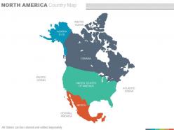
Maps of north america continent region countries in powerpoint
If you are interested to make a Presentation on the third largest continent of the world’s continents Lies in between the most part of arctic circle and the tropic of cancer, So use our maps of north America continent region countries in PowerPoint . You can use this flat PowerPoint image to explain the geographical limits which makes it one of the unique continent surrounded by the infinite natural resources like Pacific Ocean, Arctic Ocean, Atlantic Ocean, Caribbean Sea which makes it quite productive and developed one. With this PPT Design you can describe the features of the countries such as USA, Canada , Mexico , Alaska lying within the continent like its governmental and administrative policies, their cultural values of the indigenous people , education system, health care sector, countries International relations, history of the nation, about its national flag and emblem, art and literature etc. So just start preparing an alluring PPT template about the wonderful continent.Have a hassle free experience with our Maps Of North America Continent Region Countries In Powerpoint.They enable easy functioning.
You must be logged in to download this presentation.
 Impress your
 audience
Editable
of Time
PowerPoint presentation slides
Specially enhanced PowerPoint templates, Exceptional vector based map PPT designs, Reorganize able shades, region, layouts, text, fonts size, PPT images etc, Vector based formats, Fully redesign able Presentation graphics with elasticity to insert data , Appropriate for social science students, researchers ,anthropologists etc., Convertible to PDF or JPG formats, Screen layout can be changed with click on Google slides.The stages in this process are arctic ocean, alaska, pacific ocean, canada, united states of america, central america, mexico, atlantic ocean.
People who downloaded this PowerPoint presentation also viewed the following :
Maps of north america continent region countries in powerpoint with all 21 slides:
Right thoughts lead to right deeds. Our Maps Of North America Continent Region Countries In Powerpoint provide the link.
-
Best Representation of topics, really appreciable.
-
Colors used are bright and distinctive.


