Powerpoint Templates and Google slides for Map With Countries
Save Your Time and attract your audience with our fully editable PPT Templates and Slides.
-
 Australia continents powerpoint maps with act territory
We are proud to present our australia continents powerpoint maps with act territory. Our Australia Continents PowerPoint Maps with ACT Territory Power Point Templates Are Topically Designed To Provide An Attractive Backdrop To Any Subject. Use Them To Look Like A Presentation Pro. Use Our Australia Continents PowerPoint Maps with ACT Territory Power Point Templates To Effectively Help You Save Your Valuable Time. They Are Readymade To Fit Into Any Presentation Structure.
-
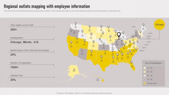 Cross Border Approach Regional Outlets Mapping With Employee Information Strategy SS V
This slide covers an international presence map of all food outlets.It also includes information such as total outlets across the market, headquarters, market share, etc. Introducing Cross Border Approach Regional Outlets Mapping With Employee Information Strategy SS V to increase your presentation threshold. Encompassed with One stages, this template is a great option to educate and entice your audience. Dispence information on Headquarters, Market Share, Number Of Employees using this template. Grab it now to reap its full benefits.
-
 Transnational Strategy For International Regional Outlets Mapping With Employee Strategy SS V
This slide covers an international presence map of all food outlets. It also includes information such as total outlets across the market, headquarters, market share, etc. Increase audience engagement and knowledge by dispensing information using Transnational Strategy For International Regional Outlets Mapping With Employee Strategy SS V This template helps you present information on One stages. You can also present information on Food Market, Headquarters, Market Share using this PPT design. This layout is completely editable so personaize it now to meet your audiences expectations.
-
 Transnational Strategy Regional Outlets Mapping With Employee Information Strategy SS V
This slide covers an international presence map of all food outlets. It also includes information such as total outlets across the market, headquarters, market share, etc. Introducing Transnational Strategy Regional Outlets Mapping With Employee Information Strategy SS V to increase your presentation threshold. Encompassed with one stage, this template is a great option to educate and entice your audience. Dispence information on Regional Outlets, Mapping With Employee, Information using this template. Grab it now to reap its full benefits.
-
 Map Of Denmark Bordered Regions With Name
This slide shows map of Denmark country with bordered regions like North Jutland, Central Denmark, Hovedstand, Southern Denmark and Zealand. Presenting our set of slides with Map Of Denmark Bordered Regions With Name. This exhibits information on three stages of the process. This is an easy to edit and innovatively designed PowerPoint template. So download immediately and highlight information on North Jutland, Hovedstaden.
-
 Map Of China Country With Cities Name
This slide shows map of China country with all area and cities name such as Urumqi, Harbin, Hong Kong and Kashkar etc. Presenting our set of slides with Map Of China Country With Cities Name. This exhibits information on three stages of the process. This is an easy to edit and innovatively designed PowerPoint template. So download immediately and highlight information on Map Of China, Country With Cities Name.
-
 Map Of China With Surrounding Countries Name
This slide shows map of China country with international boundaries of neighbouring countries such as Mongolia, India and Russia etc. Presenting our set of slides with Map Of China With Surrounding Countries Name. This exhibits information on four stages of the process. This is an easy to edit and innovatively designed PowerPoint template. So download immediately and highlight information on Map Of China, Surrounding Countries Name.
-
 France Country Map With States Name
Presenting our set of slides with France Country Map With States Name. This exhibits information on three stages of the process. This is an easy to edit and innovatively designed PowerPoint template. So download immediately and highlight information on France Country Map, States Name.
-
 France Regional Map With Eight Zones
Introducing our premium set of slides with France Regional Map With Eight Zones. Ellicudate the three stages and present information using this PPT slide. This is a completely adaptable PowerPoint template design that can be used to interpret topics like France Regional Map, Eight Zones. So download instantly and tailor it with your information.
-
 Political France Map With Regions Name
Introducing our premium set of slides with Political France Map With Regions Name. Ellicudate the three stages and present information using this PPT slide. This is a completely adaptable PowerPoint template design that can be used to interpret topics like Political France Map, Regions Name. So download instantly and tailor it with your information.
-
 Brazil Country Map With Neighbouring Countries
Introducing our premium set of slides with Brazil Country Map With Neighbouring Countries. Ellicudate the three stages and present information using this PPT slide. This is a completely adaptable PowerPoint template design that can be used to interpret topics like Brazil Country Map, Neighbouring Countries. So download instantly and tailor it with your information.
-
 Brazilian Country Map With State Borders
Presenting our set of slides with Brazilian Country Map With State Borders. This exhibits information on four stages of the process. This is an easy to edit and innovatively designed PowerPoint template. So download immediately and highlight information on Brazilian Country Map, State Borders.
-
 Unlabeled Map Of Africa Continent With Ethiopia
Introducing our premium set of slides with Unlabeled Map Of Africa Continent With Ethiopia. Ellicudate the three stages and present information using this PPT slide. This is a completely adaptable PowerPoint template design that can be used to interpret topics like Unlabeled Map Of Africa, Continent With Ethiopia. So download instantly and tailor it with your information.
-
 Map Of Eastern Asia With Labelled Countries
Introducing our premium set of slides with Map Of Eastern Asia With Labelled Countries. Ellicudate the six stages and present information using this PPT slide. This is a completely adaptable PowerPoint template design that can be used to interpret topics like Map Of Eastern Asia, Labelled Countries. So download instantly and tailor it with your information.
-
 Map Of Europe And Asia With Country Highlights
Presenting our set of slides with Map Of Europe And Asia With Country Highlights. This exhibits information on two stages of the process. This is an easy to edit and innovatively designed PowerPoint template. So download immediately and highlight information on Country, Map, Highlights.
-
 Map Of Europe And Asia With Geographic Layout
Introducing our premium set of slides with Map Of Europe And Asia With Geographic Layout. Ellicudate the two stages and present information using this PPT slide. This is a completely adaptable PowerPoint template design that can be used to interpret topics like Geographic, Layout, Map. So download instantly and tailor it with your information.
-
 Africa Map With Egypt And Other Travel Countries
Presenting our set of slides with Africa Map With Egypt And Other Travel Countries. This exhibits information on three stages of the process. This is an easy to edit and innovatively designed PowerPoint template. So download immediately and highlight information on Map, Countries, Travel.
-
 Regional Outlets Mapping With Employee Information Worldwide Approach Strategy SS V
This slide covers an international presence map of all food outlets. It also includes information such as total outlets across the market, headquarters, market share, etc. Present the topic in a bit more detail with this Regional Outlets Mapping With Employee Information Worldwide Approach Strategy SS V. Use it as a tool for discussion and navigation on Headquarters, Employees. This template is free to edit as deemed fit for your organization. Therefore download it now.
-
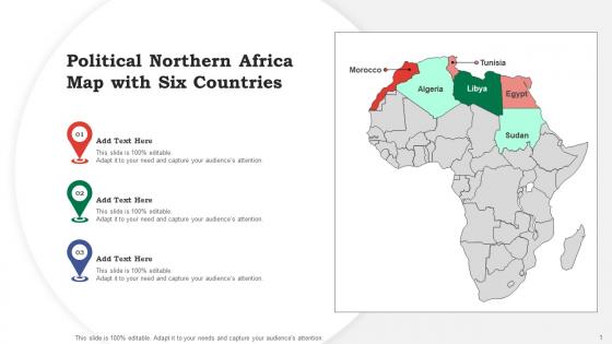 Political Northern Africa Map With Six Countries
Presenting our set of slides with Northern Africa Map. This exhibits information on three stages of the process. This is an easy to edit and innovatively designed PowerPoint template. So download immediately and highlight information on Northern, Political, Countries.
-
 Regional Outlets Mapping With Employee Information Globalization Strategy To Expand Strategt SS V
This slide covers an international presence map of all food outlets. It also includes information such as total outlets across the market, headquarters, market share, etc. Increase audience engagement and knowledge by dispensing information using Regional Outlets Mapping With Employee Information Globalization Strategy To Expand Strategt SS V. This template helps you present information on one stage. You can also present information on Regional Outlets, Mapping With Employee Information using this PPT design. This layout is completely editable so personaize it now to meet your audiences expectations.
-
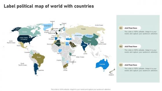 Label Political Map Of World With Countries
Introducing our premium set of slides with Label Political Map Of World With Countries. Ellicudate the three stages and present information using this PPT slide. This is a completely adaptable PowerPoint template design that can be used to interpret topics like Label Political Map, World With Countries. So download instantly and tailor it with your information.
-
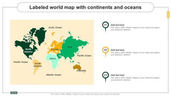 Labeled World Map With Continents And Oceans
Presenting our set of slides with Labeled World Map With Continents And Oceans This exhibits information on three stages of the process. This is an easy to edit and innovatively designed PowerPoint template. So download immediately and highlight information on Labeled World Map, Continents And Oceans.
-
 Blank Map Of Georgia Country With Bordered Regions
Presenting our set of slides with Blank Map Of Georgia Country With Bordered Regions. This exhibits information on three stages of the process. This is an easy to edit and innovatively designed PowerPoint template. So download immediately and highlight information on Blank, Bordered, Regions.
-
 Map Of Georgia With Bordered Regions Names
Presenting our set of slides with Map Of Georgia With Bordered Regions Names. This exhibits information on three stages of the process. This is an easy to edit and innovatively designed PowerPoint template. So download immediately and highlight information on Regions, Georgia, Bordered.
-
 Map Of Japan With Surrounding Countries Border
This slide shows map of Japan country with international boundaries like South Korea, North Korea and Taiwan etc along with water bodies such as Pacific ocean Presenting our set of slides with Map Of Japan With Surrounding Countries Border. This exhibits information on three stages of the process. This is an easy to edit and innovatively designed PowerPoint template. So download immediately and highlight information on International, Surrounding, Map.
-
 Asia Pacific Countries Map With Basic Information
Presenting our set of slides with Asia Pacific Countries Map With Basic Information. This exhibits information on four stages of the process. This is an easy to edit and innovatively designed PowerPoint template. So download immediately and highlight information on Area, Population, Density.
-
 Asia Pacific Countries Map With Text Holders
Introducing our premium set of slides with Asia Pacific Countries Map With Text Holders. Ellicudate the three stages and present information using this PPT slide. This is a completely adaptable PowerPoint template design that can be used to interpret topics like Asia Pacific Countries Map, Text Holders. So download instantly and tailor it with your information.
-
 Canary Islands Map Of Spain With Surrounding Countries
This slide shows location of Spanish Canary Islands with respect to capital city of Spain with name of surrounding countries such as France and Italy. Introducing our premium set of slides with Canary Islands Map Of Spain With Surrounding Countries. Ellicudate the four stages and present information using this PPT slide. This is a completely adaptable PowerPoint template design that can be used to interpret topics like Canary Islands Map Of Spain, Surrounding Countries. So download instantly and tailor it with your information.
-
 Map Of Northern Spain With Regions Name
This slide shows all regions in Northern part of Spain which are Galacia, Asturias and Cantabria etc along with borders of surrounding countries and nearby water bodies. Presenting our set of slides with Map Of Northern Spain With Regions Name. This exhibits information on four stages of the process. This is an easy to edit and innovatively designed PowerPoint template. So download immediately and highlight information on Map Of Northern Spain, Regions Name.
-
 Map Of Southern Spain With Regions Name
This slide shows map of southern regions in Spain which are Costa De La Luz, Costa Del Sol, Costa Tropical and Inland Southern Spain etc. Introducing our premium set of slides with Map Of Southern Spain With Regions Name. Ellicudate the four stages and present information using this PPT slide. This is a completely adaptable PowerPoint template design that can be used to interpret topics like Map Of Southern Spain, Regions Name. So download instantly and tailor it with your information.
-
 Map Of Spain With Name Of All Regions And States
This slide shows map of Spain with bordered states name, provinces and islands such as Murcia, Aragon, Madrid and Canary islands. Introducing our premium set of slides with Map Of Spain With Name Of All Regions And States. Ellicudate the two stages and present information using this PPT slide. This is a completely adaptable PowerPoint template design that can be used to interpret topics like Map Of Spain With Name, All Regions And States. So download instantly and tailor it with your information.
-
 Map Of Switzerland Country With Cities Name
This slide shows map of Switzerland country with name of bordered cities name and regions alon with name of surrounding countries such as Italy and France. Presenting our set of slides with Map Of Switzerland Country With Cities Name. This exhibits information on two stages of the process. This is an easy to edit and innovatively designed PowerPoint template. So download immediately and highlight information on Map Of Switzerland Country, Cities Name.
-
 Map Of Switzerland With Surrounding Countries Name
This slide shows map of Switzerland country with international borders of neighbouring countries such as France, Italy and Germany. Introducing our premium set of slides with Map Of Switzerland With Surrounding Countries Name. Ellicudate the three stages and present information using this PPT slide. This is a completely adaptable PowerPoint template design that can be used to interpret topics like Map Of Switzerland, Surrounding Countries Name. So download instantly and tailor it with your information.
-
 Blank Map Of Uk With Country Borders
This slide shows United Kingdom map with political boundaries of all four countries England, Scotland, Wales and Northern Ireland. Presenting our set of slides with Blank Map Of Uk With Country Borders. This exhibits information on three stages of the process. This is an easy to edit and innovatively designed PowerPoint template. So download immediately and highlight information on Blank Map Of Uk, Country Borders.
-
 England Regional Map With Neighboring Uk Countries
This slide shows nine regions of England as northern, southern, eastern and western parts with surrounding UK countries which are Northern Ireland, Scotland and Wales. Introducing our premium set of slides with England Regional Map With Neighboring Uk Countries. Ellicudate the three stages and present information using this PPT slide. This is a completely adaptable PowerPoint template design that can be used to interpret topics like England Regional Map, Neighboring Uk Countries. So download instantly and tailor it with your information.
-
 Great Britain Map With Labelled Countries
This slide shows map of Great Britain in UK with name of three bordered countries Scotland, Wales and England. Presenting our set of slides with Great Britain Map With Labelled Countries. This exhibits information on three stages of the process. This is an easy to edit and innovatively designed PowerPoint template. So download immediately and highlight information on Great Britain Map, Labelled Countries.
-
 Highland Map With Other Regions In Scotland
This slide shows labelled Highland area that covers an area of 25,657 km with other bordered regions in Scotland. Introducing our premium set of slides with Highland Map With Other Regions In Scotland. Ellicudate the four stages and present information using this PPT slide. This is a completely adaptable PowerPoint template design that can be used to interpret topics like Highland Map, Other Regions In Scotland. So download instantly and tailor it with your information.
-
 UK Country Map With Name Of Four Countries
This slide shows map of United kingdom with four countries which consist England, Scotland, Wales and Northern Ireland. Presenting our set of slides with UK Country Map With Name Of Four Countries. This exhibits information on three stages of the process. This is an easy to edit and innovatively designed PowerPoint template. So download immediately and highlight information on UK Country Map, Name Of Four Countries.
-
 New Zealand Regions Map With Borders
This slide shows map of New Zealand country with name of bordered regions like Northland, Auckland, Tasman and Southland. Introducing our premium set of slides with New Zealand Regions Map With Borders. Ellicudate the three stages and present information using this PPT slide. This is a completely adaptable PowerPoint template design that can be used to interpret topics like New Zealand Regions, Map With Borders. So download instantly and tailor it with your information.
-
 East Asia And The Pacific Map With Change In Net Wealth By Country
Introducing our premium set of slides with East Asia And The Pacific Map With Change In Net Wealth By Country. Ellicudate the One stages and present information using this PPT slide. This is a completely adaptable PowerPoint template design that can be used to interpret topics like Location Map, Change In Net Wealth By Country. So download instantly and tailor it with your information.
-
 Map Of Oman With Surrounding Countries Border
This slide shows marked area of Batinah governorate in country of Oman with other bordered area and regions. Presenting our set of slides with Map Of Oman With Surrounding Countries Border. This exhibits information on three stages of the process. This is an easy to edit and innovatively designed PowerPoint template. So download immediately and highlight information on Map Of Oman, Surrounding Countries Border.
-
 Highlighted Map Of Russia With Neighbouring Countries
This slide shows outlined map of Russia with international boundaries and surrounding countries name such as Japan, Finland and Mongolia. Presenting our set of slides with Highlighted Map Of Russia With Neighbouring Countries. This exhibits information on four stages of the process. This is an easy to edit and innovatively designed PowerPoint template. So download immediately and highlight information on Blank Map Of Russia, Russia Map With Surrounding Countries, Ancient Russian Empire Map, Russia Railways Network Map, Russia Population Density Map.
-
 Russia Country Map With Name Of States
This slide shows map of Russia with name of 22 states and their political boundaries such as Baikal, Pomorye and Kama along with coastal boundary. Introducing our premium set of slides with Russia Country Map With Name Of States. Ellicudate the four stages and present information using this PPT slide. This is a completely adaptable PowerPoint template design that can be used to interpret topics like Blank Map Of Russia, Russia Map With Surrounding Countries, Ancient Russian Empire Map, Russia Railways Network Map, Russia Population Density Map. So download instantly and tailor it with your information.
-
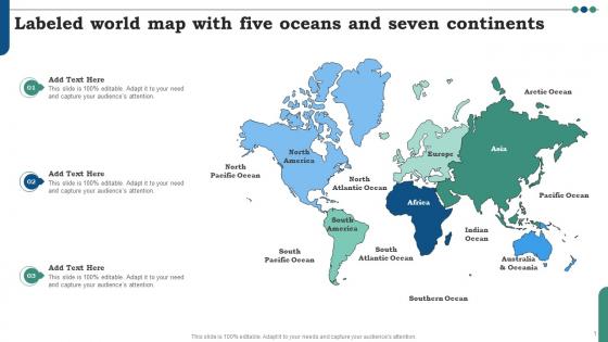 Labeled World Map With Five Oceans And Seven Continents
Presenting our set of slides with Labeled World Map With Five Oceans And Seven Continents. This exhibits information on three stages of the process. This is an easy to edit and innovatively designed PowerPoint template. So download immediately and highlight information on World Map With Oceans And Seas, Political World Map With Oceans, Political Map Of The World, World Map Outline.
-
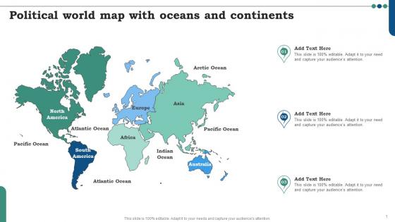 Political World Map With Oceans And Continents
Introducing our premium set of slides with Political World Map With Oceans And Continents. Ellicudate the three stages and present information using this PPT slide. This is a completely adaptable PowerPoint template design that can be used to interpret topics like World Map With Oceans And Seas, Political World Map With Oceans, Political Map Of The World, World Map Outline. So download instantly and tailor it with your information.
-
 India Map With Name Of Six Regions And Zones
This slide shows map of India with border of all six regions and zones, which are northern, central, eastern, north eastern, western and southern regions. Presenting our set of slides with India Map With Name Of Six Regions And Zones. This exhibits information on four stages of the process. This is an easy to edit and innovatively designed PowerPoint template. So download immediately and highlight information on India Map With Name, Six Regions And Zones.
-
 Map Of India Country With States Name
This slide shows map of India country with name of bordered states and union territories such as Jammu and Kashmir, Himachal Pradesh and Punjab etc. Presenting our set of slides with Map Of India Country With States Name. This exhibits information on three stages of the process. This is an easy to edit and innovatively designed PowerPoint template. So download immediately and highlight information on Map Of India Country, States Name.
-
 Map Of Union Territories In India With Surrounding Countries
This slide shows map of India with union territories name with international boundaries of neighbouring countries such as Nepal, Bhutan and Bangladesh etc. Presenting our set of slides with Map Of Union Territories In India With Surrounding Countries. This exhibits information on four stages of the process. This is an easy to edit and innovatively designed PowerPoint template. So download immediately and highlight information on Map Of Union Territories, Surrounding Countries.
-
 Asia Countries Map With Different Colors
Presenting our set of slides with Asia Countries Map With Different Colors This exhibits information on one stages of the process. This is an easy to edit and innovatively designed PowerPoint template. So download immediately and highlight information on Asia Physical Map, Asia Colored Map, Asia Labelled Map, Asia Continent Outline
-
 Landmark Sign With Egypt Flag On Country Map
Presenting our set of slides with Landmark Sign With Egypt Flag On Country Map This exhibits information on three stages of the process. This is an easy to edit and innovatively designed PowerPoint template. So download immediately and highlight information on Landmark Sign, Egypt Flag On Country Map
-
 Map Of Egypt With Local Administrative Region Names
Presenting our set of slides with Map Of Egypt With Local Administrative Region Names This exhibits information on three stages of the process. This is an easy to edit and innovatively designed PowerPoint template. So download immediately and highlight information on Map Of Egypt, Local Administrative Region Names
-
 Map Of Egypt With Regional Territory Names
Presenting our set of slides with Map Of Egypt With Regional Territory Names This exhibits information on four stages of the process. This is an easy to edit and innovatively designed PowerPoint template. So download immediately and highlight information on Map Of Egypt, Regional Territory Names
-
 Asia Pacific Region Map With Capitals By Country
Presenting our set of slides with Asia Pacific Region Map With Capitals By Country. This exhibits information on four stages of the process. This is an easy to edit and innovatively designed PowerPoint template. So download immediately and highlight information on Capitals By Country, Text Holders.
-
 Asia Pacific Region Map With Text Holders
Introducing our premium set of slides with Asia Pacific Region Map With Text Holders. Ellicudate the four stages and present information using this PPT slide. This is a completely adaptable PowerPoint template design that can be used to interpret topics like Capitals By Country, Text Holders. So download instantly and tailor it with your information.
-
 Blank Map Of Singapore With Regional Borders
This slide shows map of Singapore country with border of five regions and islands that constitute a total area of around 728.6 km Presenting our set of slides with Blank Map Of Singapore With Regional Borders. This exhibits information on three stages of the process. This is an easy to edit and innovatively designed PowerPoint template. So download immediately and highlight information on Singapore, Borders, Regional.
-
 Singapore Map With Five Bordered Regions
This slide shows Singapore regional map with name of five bordered regions, which are West, North, North East, East and Central etc Introducing our premium set of slides with Singapore Map With Five Bordered Regions. Ellicudate the five stages and present information using this PPT slide. This is a completely adaptable PowerPoint template design that can be used to interpret topics like Bordered, Map, Regions. So download instantly and tailor it with your information.
-
 Map Of UAE Country With Surrounding Countries
This slide shows country of United Arab Emirates with international borders of surrounding countries like Saudi Arabia, Oman and Qatar Introducing our premium set of slides with Map Of UAE Country With Surrounding Countries. Ellicudate the three stages and present information using this PPT slide. This is a completely adaptable PowerPoint template design that can be used to interpret topics like Country, Surrounding, Countries. So download instantly and tailor it with your information.
-
 Regional Outlets Mapping With Employee Information Global Business Strategies Strategy SS V
This slide covers an international presence map of all food outlets. It also includes information such as total outlets across the market, headquarters, market share, etc. Increase audience engagement and knowledge by dispensing information using Regional Outlets Mapping With Employee Information Global Business Strategies Strategy SS V. This template helps you present information on one stage. You can also present information on Regional Outlets Mapping, Employee Information using this PPT design. This layout is completely editable so personaize it now to meet your audiences expectations.
-
 Qatar Map With Bordered Regions Name
This slide shows map of all bordered regions and areas in Qatar country with surrounding countries name such as Saudi Arabia and Bahrain Presenting our set of slides with Qatar Map With Bordered Regions Name. This exhibits information on three stages of the process. This is an easy to edit and innovatively designed PowerPoint template. So download immediately and highlight information on Map, Regions, Countries.
-
 Qatar Physical Map With Surrounding Countries
This slide shows physical map of Qatar country that includes coastal salt pans, elevated limestone formations and sand dunes along with surrounding countries such as Bahrain and Saudi Arabia Introducing our premium set of slides with Qatar Physical Map With Surrounding Countries. Ellicudate the three stages and present information using this PPT slide. This is a completely adaptable PowerPoint template design that can be used to interpret topics like Physical, Surrounding, Countries. So download instantly and tailor it with your information.


