Powerpoint Templates and Google slides for Geospatial Data
Save Your Time and attract your audience with our fully editable PPT Templates and Slides.
-
 Geospatial Data Intelligence Industry Market Overview
This slide provides the statistical data for geospatial analytics industry to help understand the growth potential. It provides information such as market restraining factors, key market players, CAGR, etc. Presenting our well structured Geospatial Data Intelligence Industry Market Overview The topics discussed in this slide are Prominent Market Players, Restraint Factors, Market OverviewThis is an instantly available PowerPoint presentation that can be edited conveniently. Download it right away and captivate your audience.
-
 Organizing Feature Map Geospatial Data Visualization Illustration
This coloured PowerPoint icon is a great visual aid for organizing feature maps. It is a simple, easy to use template with a bright, colourful design that will help you organize your ideas in a clear and concise way.
-
 Geospatial Data Analysis In Powerpoint And Google Slides Cpb
Presenting our Geospatial Data Analysis In Powerpoint And Google Slides Cpb PowerPoint template design. This PowerPoint slide showcases four stages. It is useful to share insightful information on Geospatial Data Analysis This PPT slide can be easily accessed in standard screen and widescreen aspect ratios. It is also available in various formats like PDF, PNG, and JPG. Not only this, the PowerPoint slideshow is completely editable and you can effortlessly modify the font size, font type, and shapes according to your wish. Our PPT layout is compatible with Google Slides as well, so download and edit it as per your knowledge.
-
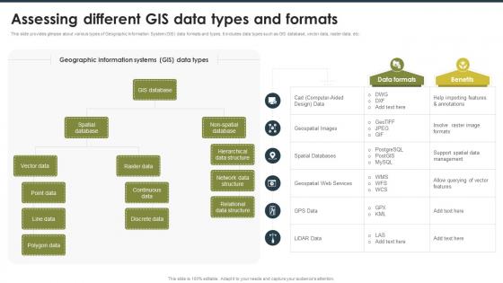
 Assessing Different GIS Data Types And Formats Geospatial Technology For Environment Conservation TC SS
This slide provides glimpse about various types of Geographic Information System GIS data formats and types. It includes data types such as GIS database, vector data, raster data, etc. Increase audience engagement and knowledge by dispensing information using Assessing Different GIS Data Types And Formats Geospatial Technology For Environment Conservation TC SS. This template helps you present information on two stages. You can also present information on Geographic Information Systems, Network Data Structure, Relational Data Structure using this PPT design. This layout is completely editable so personaize it now to meet your audiences expectations.
-
 Assessing Various GIS Data Analysis And Geospatial Technology For Environment Conservation TC SS
This slide provides glimpse about various tools that can help professionals in analysing and visualizing Geographic Information System GIS data. It includes aspects such as spatial analysis features, statistical analysis features, etc. Present the topic in a bit more detail with this Assessing Various GIS Data Analysis And Geospatial Technology For Environment Conservation TC SS. Use it as a tool for discussion and navigation on Statistical Analysis Features, Visualization Capabilities, User Interface. This template is free to edit as deemed fit for your organization. Therefore download it now.
-
 Assessing Various Steps For GIS Data Geospatial Technology For Environment Conservation TC SS
This slide provides glimpse about procedural steps that can help professionals in integrating Geographic Information System GIS data. It includes steps such as data standardization, spatial integration, data transformation, etc. Increase audience engagement and knowledge by dispensing information using Assessing Various Steps For GIS Data Geospatial Technology For Environment Conservation TC SS. This template helps you present information on five stages. You can also present information on Metadata Creation, Data Transformation, Spatial Integration using this PPT design. This layout is completely editable so personaize it now to meet your audiences expectations.
-
 Multiple Methods For GIS Data Collection Geospatial Technology For Environment Conservation TC SS
This slide provides glimpse about various methods that can help professionals in Geographic Information System GIS data collection. It includes methods such as field surveys, remote sensing, light detection and ranging LiDAR, etc. Introducing Multiple Methods For GIS Data Collection Geospatial Technology For Environment Conservation TC SS to increase your presentation threshold. Encompassed with five stages, this template is a great option to educate and entice your audience. Dispence information on Light Detection And Ranging, Remote Sensing, Geocoding, using this template. Grab it now to reap its full benefits.
-
 Spatial Data Analysis To Get Geographic Data Geospatial Technology For Environment Conservation TC SS
This slide provides glimpse about summary of spatial data analysis and modelling that helps in generating deeper insights from geographic data. It includes benefits such as urban planning, environmental studies, etc. Increase audience engagement and knowledge by dispensing information using Spatial Data Analysis To Get Geographic Data Geospatial Technology For Environment Conservation TC SS. This template helps you present information on four stages. You can also present information on Urban Planning, Environmental Studies, Disaster Management using this PPT design. This layout is completely editable so personaize it now to meet your audiences expectations.
-
 Geospatial data collection ppt powerpoint presentation ideas slide download cpb
Presenting Geospatial Data Collection Ppt Powerpoint Presentation Ideas Slide Download Cpb slide which is completely adaptable. The graphics in this PowerPoint slide showcase eight stages that will help you succinctly convey the information. In addition, you can alternate the color, font size, font type, and shapes of this PPT layout according to your content. This PPT presentation can be accessed with Google Slides and is available in both standard screen and widescreen aspect ratios. It is also a useful set to elucidate topics like Geospatial Data Collection. This well-structured design can be downloaded in different formats like PDF, JPG, and PNG. So, without any delay, click on the download button now.


