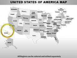
Usa hawaii state powerpoint maps
Sweeten the pill with our USA Hawaii State Powerpoint Maps. Tell them how to remove the ills.
You must be logged in to download this presentation.
 Impress your
 audience
Editable
of Time
PowerPoint presentation slides
These high quality, editable powerpoint state maps have been carefully created by our professional team to display location and other geographic details in your PowerPoint presentation. Each map is vector based and is 100% editable in powerpoint. Each and every property of any region - color, size, shading etc can be modified to help you build an effective powerpoint presentation. Use these maps to show sales territories, business and new office locations, travel planning etc in your presentations. Any text can be entered at any point in the powerpoint map slide. Simply DOWNLOAD, TYPE and PRESENT!
People who downloaded this PowerPoint presentation also viewed the following :
Content of this Powerpoint Presentation
Slide 1: This slide shows Map of UNITED STATES OF AMERICA with all 50 states and the federal district, highlighting Hawaii.
Slide 2: This is another map of UNITED STATES OF AMERICA with short form of states names.
Slide 3: This slide presents HAWAII MAP displaying- HAWAII COUNTY, MAUI COUNTY, HONOLULU COUNTY, KAUAI COUNTY.
Slide 4: This is another slide of HAWAII MAP with- HAWAII COUNTY, MAUI COUNTY, HONOLULU COUNTY, KAUAI COUNTY.
Slide 5: This slide represents HAWAII MAP highlighting KAUAI COUNTY.
Slide 6: This slide shows HAWAII MAP highlighting MAUI COUNTY.
Slide 7: This slide presents HAWAII MAP highlighting HONOLULU COUNTY.
Slide 8: This slide represents HAWAII MAP highlighting HAWAII COUNTY.
Slide 9: This slide showcases HAWAII MAP with islands and additional text boxes to elaborate information.
Slide 10: This slide presents HAWAII MAP highlighting HAWAII COUNTY and KAUAI COUNTY with additional text boxes to show information.
Slide 11: This slide represents HAWAII MAP highlighting MAUI COUNTY and HONOLULU COUNTY with additional text boxes to show information.
Slide 12: This slide displays HAWAII MAP with modes of transportation to travel across various islands.
Slide 13: This slide shows HAWAII MAP with zone areas and text boxes to elaborate.
Slide 14: This slide presents HAWAII MAP highlighting HAWAII COUNTY with colour green along with text boxes to show information.
Slide 15: This slide represents HAWAII MAP highlighting MAUI COUNTY with colour blue along with text boxes to show information.
Slide 16: This slide shows HAWAII MAP highlighting KAUAI COUNTY with colour green along with text boxes to show information.
Slide 17: This slide presents HAWAII MAP hightlighting HONOLULU COUNTY with colour red along with text boxes to show information.
Slide 18: This slide represents HAWAII MAP with HAWAII COUNTY in highlight.
Slide 19: This slide shows HAWAII MAP with MAUI COUNTY in highlight.
Slide 20: This slide presents HAWAII MAP with city, Sales Representative and contact number.
Slide 21: This slide HAWAII MAP with distributors. You can change it as per requirements.
Slide 22: This slide shows how to edit or change the colours of maps.
Slide 23: This is another slide that shows how to edit or change the colours of maps.
Slide 24: This slide shows how to Edit size or change size of the maps.
Slide 25: This slide shows how to Insert names using text boxes.
Usa hawaii state powerpoint maps with all 25 slides:
Dedicate yourself to the cause. Confirm you commitment with our USA Hawaii State Powerpoint Maps.
-
Excellent template with unique design.
-
Excellent template with unique design.


